As sea-levels rise due to climate change, historical monuments and landscapes near bodies of water are at risk. A new research project will provide decision makers with information on what that could look like for their site. Specifically, the project is focused monuments and landscapes that are significant to African American, Indigenous, and other minority communities.
Transcript
INTRO: We think of sea-level rise as inundation, right? But you also have to think about the fact that water tables are rising. This causes archaeological materials to decay and ecological sites to change.
HOST: Welcome to Growing Impact, a podcast by the Institutes of Energy and the Environment at Penn State. Growing Impact explores cutting-edge projects of researchers and scientists who are solving some of the world's most challenging energy and environmental issues. Each project has been funded through an innovative seed grant program that's facilitated through IEE. I'm your host, Kevin Sliman.
HOST: On this episode of Growing Impact, I speak with Peter Stempel, an associate professor of landscape architecture at Penn State. We discuss his work with scientifically grounded, realistic visualizations. These are computer-generated representations that precisely portray the landscape’s details, as well as the scientific data. But this is more than just making amazingly accurate visualizations. As climate change continues to cause sea-level rise, there are numerous historical sites that are in jeopardy of being destroyed or altered. Peter and his team are focusing on landscapes and monuments that are culturally significant to African American, Indigenous, and other minority communities.
HOST: Thank you, Peter, for being on Growing Impact today, and welcome to the show.
Peter Stempel (PS): Thank you for having me. I'm really excited to be here.
HOST: Would you be able to provide just a general overview of the project?
PS: This project is focused on improving visualizations for engaging the public with decision-making around sea-level rise and especially cultural heritage sites. And specifically what I'm interested in is expanding the range of what we can credibly include in scientifically grounded, realistic visualizations. That's a mouthful. But I make realistic visualizations of landscapes. What we can include in those visualizations so that we can better represent cultural landscapes and ecological features that are of concern to African American communities, Indigenous people, and other minority communities.
HOST: What kinds of visualizations are you talking about?
PS: So the work I do links landscape visualization, which is depicting real places and contexts that are recognizable with varying degrees of realism. So perspectival views, light and shadow, things that you would associate with computer rendering. And what's unique about the visualizations I create is that these are linked to scientific models. I study the way, the implications of using these kinds of visualizations for communicating science. And how we can make the most effective, but also how we can maintain the credibility of science.
HOST: As the climate is changing, what are the concerns when it comes to sea-level rise?
PS: Climate change and sea-level rise has gone from a someday thing to a now thing. In terms of the National Park Service, one of the partners I'm working with, they're faced with imminent choices about countless sites that are being harmed. And we think of sea level rise as inundation, right?. But you also have to think about the fact that water tables are rising. This causes archaeological materials to decay and ecological sites to change. And to that end, the Park Service has adopted new frameworks for assessing what to protect and what to let go, as well as what to transform. All of this of course, is happening at this huge moment of cultural reckoning, right, where we're reassessing the way historic sites and monuments have been interpreted. I mean, the Civil War monument controversies are only one—the tip of the iceberg—in terms of the depth of things that have been interpreted over time and embed racist ideas, to be really frank. And we're also at a moment in terms of planning, where we're addressing what I would call the fallacy of colorblind planning—in the sense that if you have a community that embeds structural racism, say through red lining or other things—when you go to reallocate resources, let's say for sea-level adaptation, you can't just take a generic metric, apply it to the community and not perpetuate sort of racist imbalances.
HOST: Are there areas that you're thinking about that might be impacted in a more severe way?
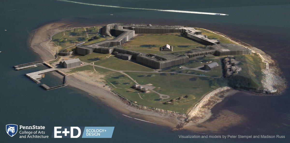
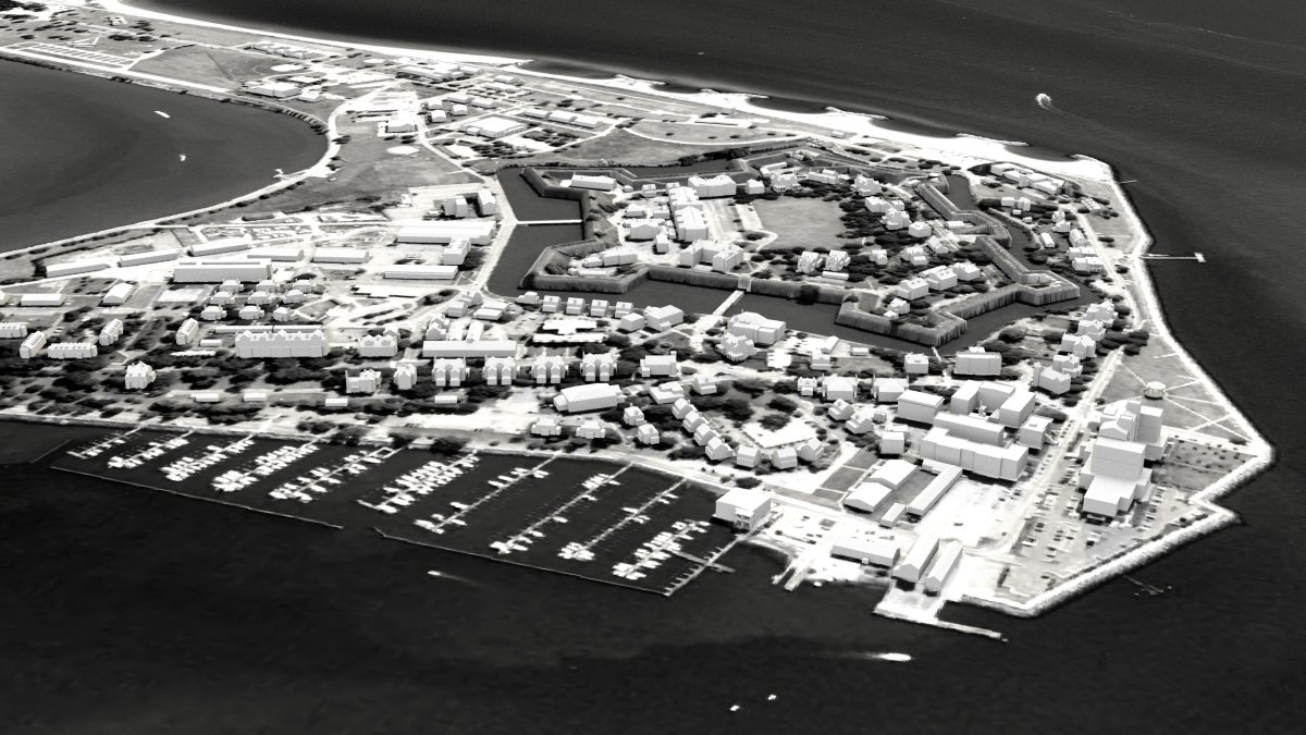
PS: So the issue we face is just the sheer volume and types of places that are affected, right? When we think about cultural heritage sites that are in danger, we often think about things like lighthouses and 19th century buildings. But when we're talking about the kinds of resources that the National Park Service has to manage, we're talking about everything from battlefields and archaeological sites to cultural landscapes which are sort of, it's not just a thing, it's a whole place and all the things that make up that place, right? And these are the kinds of resources that are difficult to protect in the conventional sense, right? We literally can't pick up and move them. Or the number that we can protect is limited just because of resources. And in some cases, the people who are most concerned with them—so for instance, certain Indigenous communities—wouldn't want us to pick up and protect that archeological site. They would prefer that it be left to decay. So the challenge that I'm concerned with is that many of these sites that I'm speaking about are the ones that are most significant to Indigenous and African American people, right? Like the Algernourne Oak, which is this tree that stood since the 16th century at Fort Monroe. And that's right near the place where the first African-Americans arrived, or first Africans, I should say, arrived in North America. So it's called a witness tree, right? There are lots of resources like that. The deserve our attention. And frankly, have a relationship to people beyond the local areas in which they exist. And I want to make sure that the tools we have to talk about these things are really up to the task.
HOST: What is it that makes you passionate about this idea of preserving these areas and are ensuring these cultures are preserved and/or respected?
PS: I've been really interested in equity and inclusion in teaching for a long time. And I have a colleague at the University of Rhode Island who went through a very extensive public engagement process and essentially did a state-of-the-art process. And in the end, was riding a ferry. And she and her colleague were asking, where have the Indigenous people gone in this place? All of the memorials and monuments in this place, sort of either neglected Indigenous people or portrayed them as extinct, right? And she had the experience of a voice saying from another seat on the ferry that we never left. Right? And she presented this at a conference. It's just chilling in the sense that we all believe strongly in the power of consultative processes and including people in these processes. And the difficulty we have is that we're fundamentally dependent on the people who show up. And it's a mistake to think that not showing up is about the people who are not showing up, in my mind. Because if people don't see themselves reflected and processes, right, they're not going to come. We really need to begin to recognize that oftentimes the way that we structure our tools and processes itself can be exclusive. I'm getting kind of into the weeds here, right? But I think this is a really important issue. So for instance, if you're interested in heritage sites and this is really now speaking outside of the Park Service. I'm speaking more broadly. Right? But if you show up to a preservation meeting, in the framework of the preservation meeting is only concerned with 19th century buildings and things meeting certain standards of conservation, if your culture has been excluded from the 19th century material culture because of racism, that pretty much says that this isn't for you. And so this is a very complex issue. It's a really difficult issue, right? But I think it's one that we need to think about. And especially if you, I think about this issue of the National Park Service. I feel like as people who are running these processes and frankly, many of us our white, right? You go to a meeting of experts and cultural resilience, and it's generally not a very diverse room. And as we work hard to get more people of color into cultural resilience, we also have to deal with this transition period of running these processes better. And so that's where I'm working on these tools. Because I want to say, Hey, wait a minute. Is there a representational bias built in the way we're using the tools and can we do better representing? That's why ultimately I'm really passionate about this idea.
HOST: How does your project propose to improve climate engagement to improve equality?
PS: So speaking broadly, it’s this idea of calibrating our tools so that we can actually bring more people with cultural stakes into the discussion. And I think the Park Service has a perfect microcosm to work with us because the people in the Park Service, right, are already so passionate about this issue of engagement, right? The Park Service is really, in my mind a leader in many ways in terms of how they're doing this. And so in some sense, this is a chance for the resilience community or at least the part of the resilience community I'm in, right, to learn a bit from the Park Service and then link it back to the science in a meaningful way.
HOST: Do you want to discuss maybe some of the tools or technology that you're utilizing in the project?
PS: I can do that briefly actually. So the most specialized aspect of what I do is, and this is very nerdy, is writing code that connects the scientific models to design visualization tools that are used to make landscape visualizations. And also designing ways to link things to make it so that model can control the representations of trees or something like that. But the thing is I think this is actually a very important thing to talk about because historically, the way visualizations have been made have been technologically driven, right—where we can do something and therefore we do it—We have this tool and therefore we use it. And so again, this project is trying to turn that on the head and say, well, what do we need to do, right? What do people want to see? And can we start to redesign the tools to better do that? Which is what I think we'd like. That's a longstanding problem within the realistic visualization area, is so much of it is been driven time after time, with every new technology based on what we can do instead of what we should do. We're at this really profound time because sea levels threatening you know, these resources that touch the soul of our country, right? Like, like the Hampton, Virginia, which is the location where this first project is taking really wonderful partners at Fort Monroe National Monument and the Park Service, right? This is really at the nexus of where colonization happened. So many historic events happened here. So In some ways I'm working this very tiny little thing, but also it's, it's hard not to think about the fact that it touches these big issues.
HOST: How does this project benefit from an interdisciplinary team?
PS: Because I'm sort of this intermediary, right? Like I'm not the expert that engages the public and I'm not the expert that does science. I'm the person who figures out how to visualize things and how to connect those things up. What's so cool about that is that I get to work with this huge cross-section of people on all the projects I do— not just this one, but on this one it's like it's really an all-star event for me because we have these state-of-the-art sea level projections from Klaus Keller, who's just been an incredible mensch for even being part of this project. And then we've got amazing people from the National Park Service who have really particular issues that they're trying to solve them. And I get to help try and you know address my research and also hopefully meet some of their very real needs for management and interpretation. And that's really nice because this is how the rubber meets the road with science, right? Where we, we have the end-users. We've got the fundamental science, right? And we get to connect it all together, right? And to me that's exciting. And it really, it also just embodies the mission of a school like Penn State being a land-grant and sea-grant institution. Where it's not just about advancing the state of the art of knowledge, but bringing it into conversation and making it make a difference in people's lives.
HOST: What are the next steps and our future plans? Do you have anything you can talk about for this project?
PS: I think that the agenda, the project is clear, right. And what we need to accomplish. And I wish we are further along this road, right, because scholars have, especially scholars who happen to be people of color, have been sounding the alarm on these issues for a long time. And quite frankly, a lot of us have been too slow, Too slow off the blocks, right? But I think there's also just a bigger thing that's also happening and that is realistic visualizations are sort of converging. We're seeing increasing real isn't a meteorological visualizations that you see on television. We're seeing advances and AR and VR and all these different things. And what's, what's happening is visualizations that used to be sort of different things or niche things are starting to converge a little bit. And I think that that's something that we need to keep our eye on in the sense that we're going to see data used and presented in these things more and more. And so what I'm really hoping is that by doing this project, now, we can start to build some guidance. And we can start to really inform and steer these things in a way that helps us maintain the credibility of scientists to not have their data misused or mischaracterized, or to mislead the public. And also at the same time allows us to really reach the broad audiences who want to reach.
HOST: Peter, thanks so much for coming on Growing Impact today and sharing about your project.
PS: Thank you. I really enjoyed the conversation and thank you for letting me talk to your audience. I really appreciate that.
HOST: You have been listening to Growing Impact, a podcast by the Institutes of Energy and the Environment at Penn State. I've been your host, Kevin Sliman. This has been season two, episode 6. Thank you for listening.
Images
Some examples of Peter Stempel's work with realistic visualizations.