
Many agricultural watersheds in the U.S. are experiencing water quality challenges due to intensive livestock agriculture. Managing livestock manure is a challenge for farmers and land managers because the area available for manure application is limited. In addition, improper manure management (manure over-application or application in areas that are highly susceptible to surface runoff or leaching) can lead to water quality and human health issues. The current recommended nutrient management plan calls for comprehensive strategies to tackle these critical management challenges. A new and effective nutrient management strategy is necessary to bolster the existing nutrient management plan (NMP) and minimize manure-driven nutrient loss.
Sustainable manure application depends on suitable locations, appropriate timing, crop demand-based application rate, and weather conditions. Although appropriate manure application can improve soil health and minimize nutrient losses, improper manure management can lead to environmental water quality issues through surface runoff and leaching. The concept of “4R Nutrient Stewardship” specifies four factors that must be considered in sustainable nutrient management: Right Source, Right Place, Right Time, and Right Rate. However, location-specific management strategies must be developed to implement the concept successfully in agricultural watersheds. This study focuses primarily on identifying the right places for sustainable manure application.
Decision-support tools that can address manure management issues are often unavailable. The N index can evaluate N leaching to the groundwater, and the P index can estimate a field’s vulnerability to P runoff among available tools. In the absence of a comprehensive decision-support tool that can identify landscape vulnerabilities to manure nutrient loss, we have developed a land suitability framework (LSF) for sustainable manure management. The LSF provides guidelines for identifying areas where manure can be safely and sustainably applied. The framework and accompanying tools will protect environmentally vulnerable lands and promote effective manure management at a regional scale.
Methods
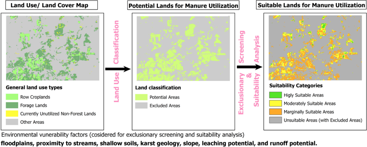
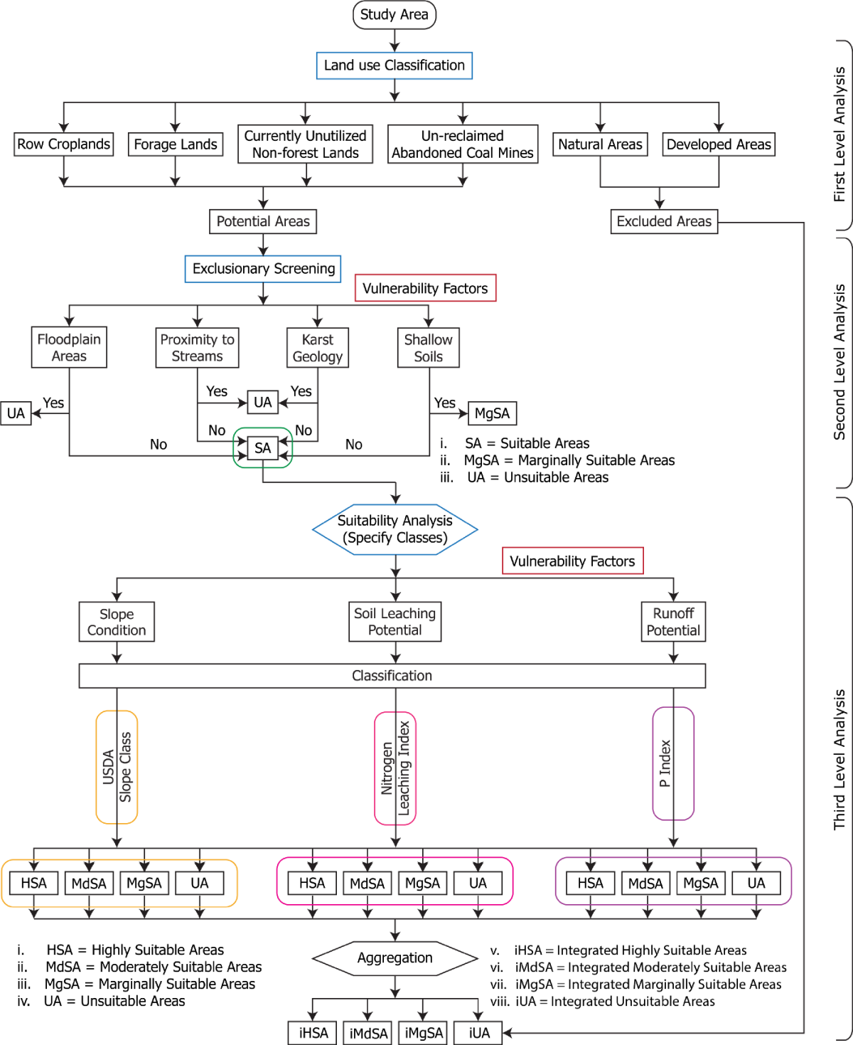
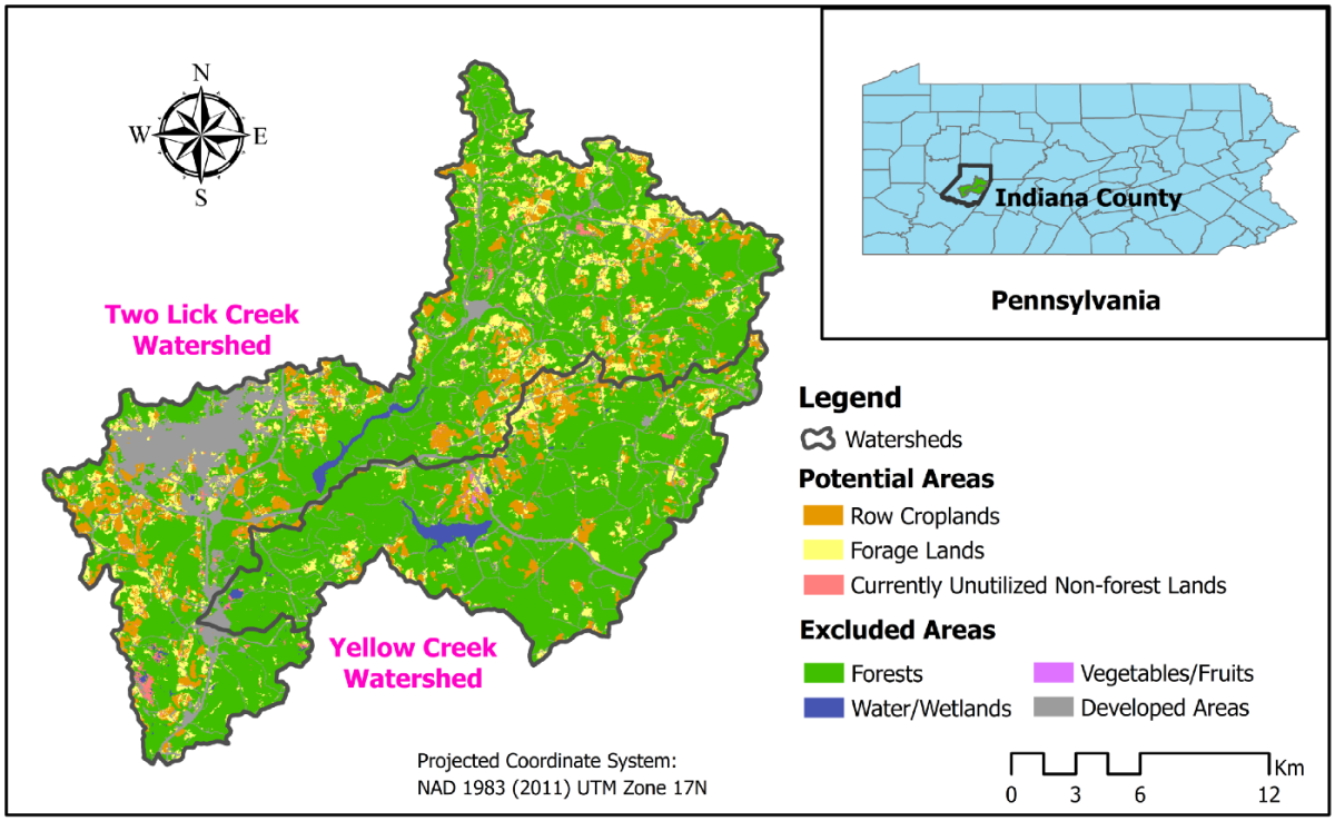
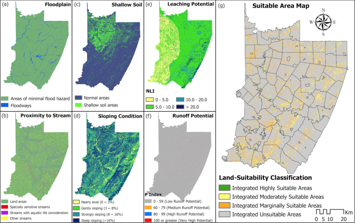
In the first part of the study, a novel tool called a land suitability framework (LSF) was developed to identify environmentally suitable areas for manure application. The LSF works in three steps: (1) land use classification, (2) exclusionary screening, and (3) suitability classification and aggregation (Figure 1). Seven environmental vulnerability factors were considered in the framework: floodplains, proximity to streams, karst geology, shallow soils, slope, leaching potential, and runoff potential. The first four vulnerability factors were evaluated on a pass-fail basis. The remaining three vulnerability factors categorized the potential areas into four suitability categories: highly suitable, moderately suitable, marginally suitable, and unsuitable areas. The LSF was applied to three Pennsylvania counties (Armstrong, Indiana, and Westmoreland) and used to identify suitable lands of different suitability categories. Several ArcGIS-based toolboxes, available at ScholarSphere (https://doi.org/10.26207/99tk-sn24), were developed to implement the LSF.
In the second part of the study, we used a small watershed in western Pennsylvania to test the consistency of the LSF (Figure 2). We developed Soil and Water Assessment Tool (SWAT) simulation scenarios based on corn as land use and synthetic fertilizers and manure as fertilization type. SWAT simulations quantified seven types of nutrient loss, including organic N and P losses, sediment-bound and soluble P losses, and nitrate loss through leaching, runoff, and lateral flow. Each agricultural land of the study area was categorized based on the suitability categories (highly suitable, moderately suitable, marginally suitable, and unsuitable) of each environmental vulnerability factor of LSF and compared the SWAT-simulated seven nutrient-loss types from the agricultural lands among suitability categories. We then utilized a decision tree to identify the combined effect of landscape biophysical characteristics on the selected seven nutrient-loss types. The decision tree analysis considered sixteen biophysical characteristics as predictor variables and seven nutrient-loss types as response variables. We developed seven decision trees showing the most sensitive biophysical characteristics for each nutrient-loss type.
Discussion and Conclusion
The case study analysis of three western Pennsylvanian counties showed that the region had 130,700 ha of potential land for sustainable manure management. About 2,524 ha (0.4% of the entire study area) and 43,754 ha (6.7% of the entire study area) were identified as highly and moderately suitable for manure application (Figure 3). Steep slope (>16%) was identified as the predominant vulnerability factor for making the potential areas unsuitable for manure application, followed by proximity to streams. Strong slope (8% to 16%), shallow soils, and high soil leaching potential (leaching index: 5–10) were crucial factors in making the potential areas marginally suitable.
The spatial analysis of land suitability classification and nutrient-loss percentile indicated that areas vulnerable to one nutrient-loss mechanism could be less vulnerable to other types of nutrient loss (Figure 4). SWAT simulations showed that 94% (2,206 ha) of the unsuitable areas had greater than the 80th percentile nutrient loss from at least one nutrient type due to manure application. However, a comparison among different nutrient-loss types from LSF-based suitability categories showed similar ranges, indicating that the LSF disregarded the combined effect of multiple vulnerability factors.
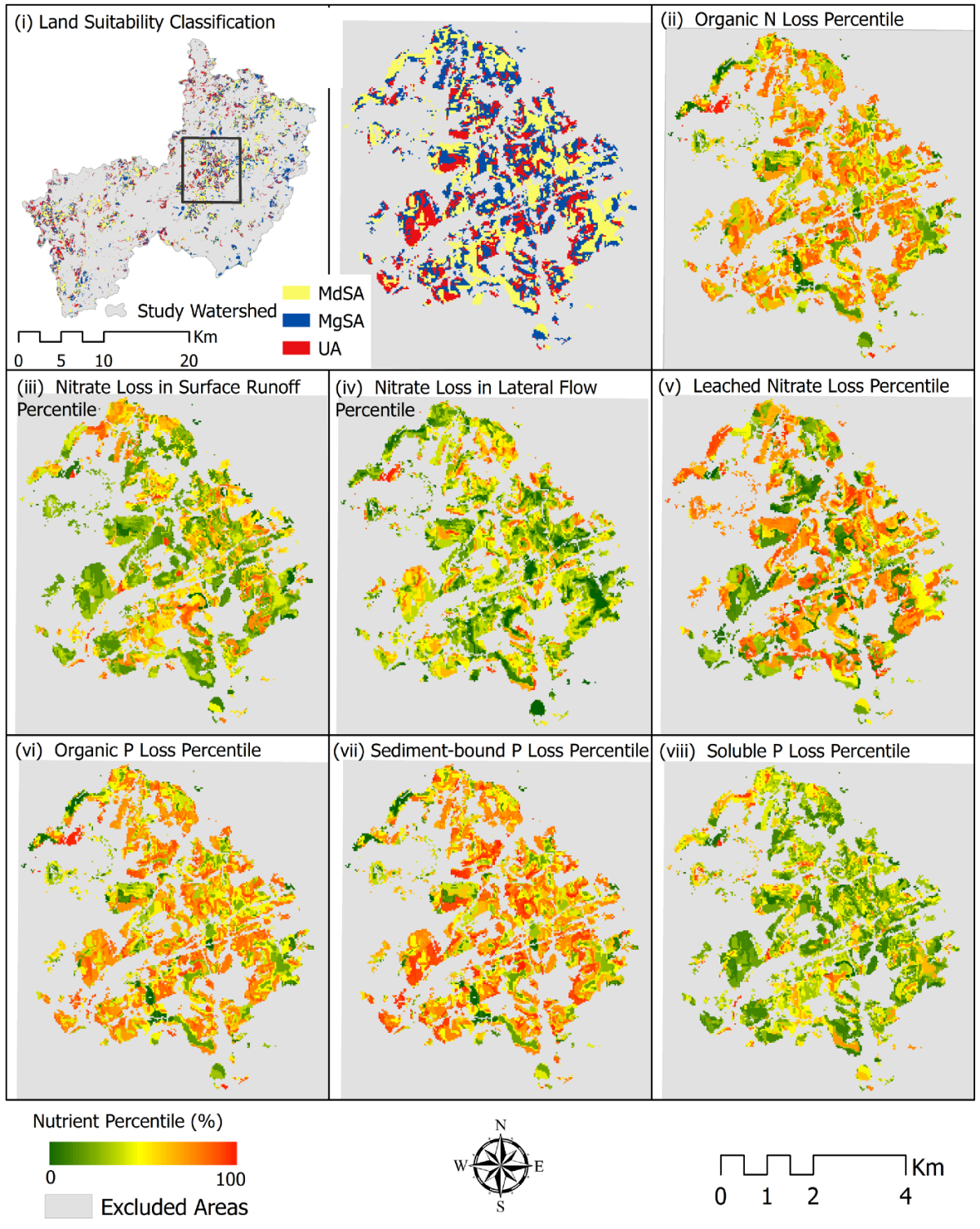
Comparison results of seven nutrient-loss types (based on their respective agricultural land’s suitability category) provide several key insights. Results indicated increasing trends in nitrate loss in lateral flow, organic N and P, and sediment-bound P loss with the change in LSF categories from highly suitable to unsuitable based on the slope (Figure 5). Coupled results of leaching potential and SWAT simulation demonstrated an increasing trend in nitrate loss from lateral flow and leaching and a decreasing trend in surface runoff from marginally suitable compared to moderately suitable areas. Runoff potential-based results showed increasing trends in organic and sediment-bound P loss when the LSF categories changed from highly suitable to unsuitable. The decision tree model results indicated that slope, specific soil series, soil depth, and hydrologic soil group influenced most nutrient-loss types. The LSF could be improved by including additional soil biophysical characteristics.
![Figure 5. Comparison of six different types of nutrient loss for slope-based land suitability classes (highly suitable area [HSA], MdSA, MgSA, and UA): (i) organic N loss, (ii) NO₃-N loss in lateral flow, (iii) NO₃-N leached, (iv) organic P loss, (v) sediment P loss, and (vi) soluble P loss. The mean represents the area-weighted average nutrient-loss values from HRUs across different suitability classes.](/sites/default/files/styles/large_1200_2400_/public/image/manure-poster-6.png?itok=ySMhGwPD)
References
Saha, G., Cibin, R, Elliott, H. A., and Preisendanz H. E. (2020). Development of a Land Suitability Framework for Sustainable Manure Utilization. Transaction of ASABE. Vol 64, Issue 1, pages 273–285. https://doi.org/10.13031/trans.14000
Saha, G (2020) Land Suitability Analysis Tools for Sustainable Manure Utilization. ScholarSphere; Penn State Libraries. https://doi.org/10.26207/99tk-sn24
Saha, G., Cibin, R, Elliott, H. A., and Preisendanz H. E. (2022) Towards a robust land suitability framework for manure management: modeling impacts and evaluating biophysical characteristics. Journal of American Water Resources Association. https://doi.org/10.1111/1752-1688.13008.
This article was originally on Medium (https://medium.com/@psuwaterstudentgroup/manure-can-be-a-resource-when-applied-in-the-right-places-853e6745b81a) and was republished with permission.